Back Home

Autonomous UAV Navigation and Geospatial Cloud Processing of UAS, UAV and Drone Data.

Autonomous UAV Navigation and Geospatial Cloud Processing of UAS, UAV and Drone Data.

  • Home
  • About Us
  • One Solution
  • Upload Data
  • My Account
  • Contact Us

3D GIS


UAV Drone Mapped – 3D Architectural Simulation – “Real World Mapping and Modeling”

This entry was posted in Mapping and tagged 3D Building Models 3D GIS 3D Photogrammetry 3D Point Cloud 3D Point Clouds 3D Urban Models Architecture Drone Drones Gaming GIS GPS Mobile GIS Mobile GPS Photogrammetry Real Estate UAS UAV on by onedronecloud (updated 3365 days ago)

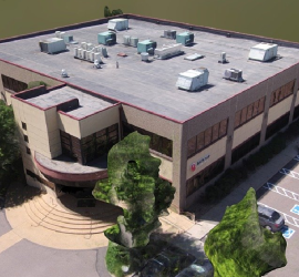
3D urban and building models produced from high resolution, stereo imagery collected with UAV – Drone platforms. Building 1690 by One Drone Cloud on Sketchfab


3D Geospatial Gaming and Simulation – 3D Photogrammetry

This entry was posted in Mapping and tagged 3D GIS 3D Photogrammetry Bing Maps GIS UAS UAV on by onedronecloud (updated 4047 days ago)

3D Geospatial Gaming – “Real World Mapping and Modeling”

This entry was posted in Mapping and tagged 3D GIS 3D Photogrammetry Bing Maps C++ HOLOLENS LiDAR Microsoft Microsoft Ultra Cam OPENGL on by onedronecloud (updated 3980 days ago)

· © 2026 One Drone Cloud - Terra Imaging LLC UAS, UAV Drone Mapping Solutions.

Back to top